|
|
| Home | Институт | Администрация | Лаборатории | Объявления | Сотрудники | Cсылки | O нас |
|
| Научные отчеты |
|
Vadim Ye. Kirillov, Institute of Tectonics and Geophysics (ITiG), FEB RAS, Kim-Y-Chen 65, 680000 Khabarovsk, Russia Vladimir Antishin Federal State Unitary Geologic Enterprise Sakhalin Geologic Prospecting Expedition, Matrosova 26, 693005 Yuzhno-Sakhalinsk, Russia Alexandr Pachin, Federal State Unitary Geologic Enterprise Sakhalin Geologic Prospecting Expedition, Matrosova 26, 693005 Yuzhno-Sakhalinsk, Russia Yuri M. Shchepotyev Central Research Institute of Geologic Prospecting for Base and Precious Metals (TsNIGRI), Varshavskoye Shosse 129b, 113545 Moscow, Russia Abstract Data is cited on the study results of gold potential of Urup Island of the Greater Kuril Range. Preliminary metallogenic zoning of the island was done, and gold-bearing fields, zones and areas were distinguished. The geologic-structural settings of gold-specialized hydrothermal-metasomatic occurrences are considered. Factors of location of mineralization are specified. It is shown that the distribution of ore-bearing metasomatites and hydrothermalites is governed by their position in the central or peripheral parts of volcano-tectonic structures or in the linear zones of NE- and NW-trending faults. Most of the particularly sizeable gold occurrences assigned to the gold-silver volcanogenic formation have been identified in the Pliocene acid subvolcanic rocks, which they are genetically linked to or gravitate toward tuffaceous-sedimentary rocks of dacite composition occurring in the bed tops of Miocene-Pliocene deposits. It has been established that in most cases the studied gold mineralization of commercial status is related to sulfide and low sulfide quartz veins or their stockworks (Kupol deposit) within the large bodies of secondary sericite quatrzites in argilllisite and propylite aureoles. The age of the ore-bearing metasomatites based on the K-Ar method is estimated at 4-10.6 Ma. The petrographic description of stages of mineral formation at the Kupol deposit is given. The main of these are metasomatic (alteration of country rocks to hydromica quartzites) and ore low sulfide quartz-vein, with the deposition of the gold-chalcopyrite-tennantite and the gold-hessite mineral association. Gold mineralization at the deposit is assigned to the gold-telluride geochemical type. The present-day ore deposition at the Otlivnoe occurrence generated by hot mineralized springs is described. INTRODUCTION 
Since 2002, a new gold district on Urup Island in the Kuril island arc (Figs 1, 2) has been recognized. This district contains the Kupol gold epithermal gold-silver deposit and about ten occurrences. Prospecting and mineragenic mapping conducted by the Sakhalin Geologic Prospecting Expedition in 2002-2004 at a scale of 1:50,000 were aimed at the study of potentially promising areas and volcanic structures. In the western part of the island they include the Shmidt area; in the northern part, Kastrikum area; and in the eastern part, Lidinskaya and Okeanskaya areas. The prospecting was accompanied with taking heavy mineral concentrate, bottom, and Уabsolute age determinableФ samples, hand specimen and furrow samples, and also rock material for microscopic analysis. The Urup Joint-Stock Mining Company proceeded prospecting and evaluation work at the Kupol deposit and its flanks (Tetyaev volcanic structure) by surface mining and drilling. Petrographic research into rock and ore composition was carried out at the Central Scientific Research Geologic Prospecting Institute (D.A. Lorents, S.V. Yablokova), Institute of Marine Geology and Geophysics (V.Ya. Danchenko, A.V. Rybin), and Sakhalin Geologic Prospecting Expedition (G.N. Rogotnev). Analytical work was conducted at the laboratories of the Research Geologic Centre (Yuzhno-Sakhalinsk), Institute of Geochemistry and Analytical Chemistry, RAS (Moscow), and УDalgeofizikaФ (Khabarovsk). Spectral, atomic absorption, assay, and microX-ray spectral analyses were basic in the investigations. Computer processing of cartographic and geochemical material was done at the Sakhalin Geologic Prospecting Expedition (V.Ye. Antishin, I.A. Kvardakov, Yu.V. Rybak-Franko, V.G. Galversen, and others). This work is aimed at illustration of the main patterns of spatial distribution of gold mineralization which has been recognized by now, and definition of structural, lithological and mineragenic factors of its location. GEOLOGIC STRUCTURE OF THE ISLAND 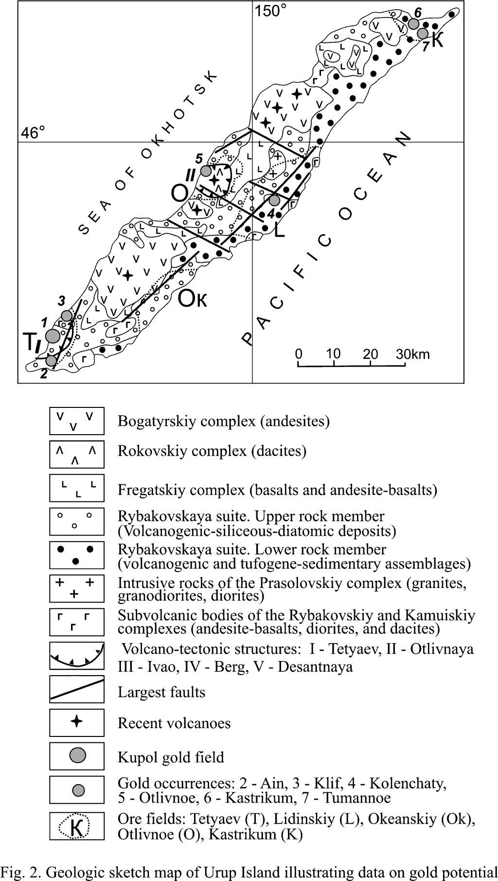
Geologic and, specifically, tectonic, stratigraphic and magmatic criteria of the location of mineralization are significant for the study area. Taking this into account, the main features of the geologic structure of the island are cited below. Urup Island covering about 1,420 km2 is located in the central part of the Greater Kuril Island Arc or Range (GKR). Two principal scientific versions are suggested for its origin. The first describes the arc as a young geosynclinal zone laid down in the Late Cretaceous and being at a relative early stage of development to this day (G.M. Vlasov et al., УYoung geosynclines†Ф, 1978; G.I. Govorov et al., УVolcanic belts†Ф, 1984). The second, more modern version explains the formation of island arcs and deep-sea trenches from the position of plate tectonics as a result of underthrust of the oceanic lithosphere plate under the continental plate in the continent-to-ocean transition zone (Kovalev, 1978; Packyam, Falvey, УNew global tectonicsФ, 1974). All the islands of the GKR have a common history of development. It is expressed in the synchronism of the main stages of tectonic processes and near simultaneity of magmatic cycles. Geomorphologically, the island is a plateau up to 200 m high with ranges of volcanic origin rising above it -- Krishtofovich, Pyotr Shmidt, Shokalskiy, and Kompaneyskiy ranges, and also some groups of volcanoes (Cape Shauten area). The height of the mountain structures reaches 1,300 m. Tectonic features. Just as other largest islands of the GKR, Urup is described as a Quaternary horst structure. This is indicated by the position of the Early Quaternary (Early Pleistocene) leveling plane on the Upper Miocene-Pliocene marine tuffaceous-sedimentary deposits at a height of 100-200 m above sea level. The periclinal dip of the stratified volcanogenic-sedimentary rocks, especially noticeable on the western and eastern coast of the island, may be evidence of the development of the structure as a horst-anticlinorium rise. The transverse asymmetry of the anticlinorium is indicated by the dip angles of rocks observed in different parts of the island. For example, in the Sea of Okhotsk area, the bed tops of the tuffaceous-sedimentary section are exposed which have a rather high-angle (30-40°) NW dip of the beds. The Pacific flank of the anticlinorium shows the predominance of gently E-dipping (5-15°) tuffaceous-sedimentary rocks of the section bottom. Generally, this regularity persists in the whole horst-anticlinorium structure. In some cases it changes to steeply dipping: 1) in zones of vertical faults; 2) in peripheral parts of separate volcanic structures of Recent, Holocene and Neogene-Quaternary age; and 3) on the periphery of the largest subvolcanic bodies. Besides, an indirect indicator of development of the anticlinorium rise may be gentle rupture dislocations. They include both layer-by-layer and interstratal, which have a periclinal dip with respect to the island structure, and obliquely intersecting bedding with centroclinal dip. The inner structure of the Urup horst anticlinorium has not been amply studied by now. The present-day conceptions of tectonics, stratigraphy and magmatism are based on geologic prospecting at a scale of 1:200,000 in the last 60s and 70s and additional geologic study during the last 5 years. However, the features of the structure of Holocene and Present volcanic structures alone have been interpreted fairly distinctly (Gorshkov, 1967). The older eroded structures of Pre-Quaternary age which are significant as potentially ore-bearing, require special study. Stratovolcanoes of the central type with near-apical calderas are noted among Pleistocene-Holocene and Present volcanic structures. Volcano-tectonic deformations related to volcanic structures (subsidence calderas, volcanic depressions) are presumed in the vicinity of the dacite volcano УTri SestryФ and a group of volcanoes (Trezubets, Kolokol, and Gora Nepristupnaya) (Fig.2). Small and middle-size structures prevail among eroded paleovolcanoes. Space images interpretation suggests the presence of paleocalderas in the Tokotanskiy isthmus area and in the southern part of the island. Among linear rupture dislocations, NE (20-35°) and NW (300-340°)-trending faults predominate markedly. There were vertical movements along the former system with amplitude of up to a few hundreds of meters of the upthrow and upthrow-thrust type with the displacement plane tilting NW. Along the latter system, horizontal movements prevailed. The thickness of the NE fault zones reaches several hundreds of meters; and that of the NW fault zones, a few tens of meters to 100-150 m. Both systems are neotectonically active, which is indicated by the presence of hot and cold mineralized sulfur springs that are controlled by them. Besides, the described fault zones determined the distribution of belts of intermediate to basic dikes, and hydrothermal metasomatic assemblages. The north-eastern system controls the distribution of magmatic activity centers, including volcanic structures and intrusive bodies. Among other rupture dislocations sublatitudinally-and submeridionally-striking faults are present. Stratigraphic features. To date, the stratigraphic problems of the Urup rocks have been little investigated. This problem is essential in terms of ore location significance of some units of the stratigraphic section. According to the present-day conceptions (Kovtunovich, 2003), the structure of the island is formed by the following assemblages, from bottom to top: 1) assemblages of the Rybakovskaya suite: basic and intermediate aqua tuffs and aqua tuffites, tuff sandstone, tuff gravelite, tuff conglomerates, volcanomictic breccias, conglomerates, siltstone, volcanic rock horizons of a total thickness of 2,900 m; light-green gravelite, volcanics, acid tuffites and tuffs, and also gaize-like sandstone with pyroclastic material admixture interbedded with tuff siltstone and tuff diatomite with a total thickness of over 1200 m. The age of the suite is defined as Late Miocene-Pliocene; and its tops, as Middle-Late Pliocene based on the finds of mollusk, radiolarian and diatom remains. Compositionally, the lower part of the section is more basic. The upper part is mainly dacitic; many rock differences hold a large quantity of white acid pumice fragments coloring them whitish. The deposits of the lower formation member of the Rybakovskaya suite are widespread in the eastern part of the island; and those of the upper formation member, in the central and western parts (Fig.2). The above-described assemblages formed in a marine, and to a lesser degree, in a subaerial environment. The rocks of the lower part of the section can be subdivided into the effusive-pyroclastic and volcanogenic-sedimentary facial groups. In the sediment unit, the former occur as thick УlensesФ fixing the activity of large paleovolcanic foci. The assemblages of the upper part of the section of the Rybakovskaya suite can be united into the volcanogenic-cherty-diatomic complex incorporating the volcanogenic-sedimentary and the effusive-pyroclastic group of facies. In the vertical section upward a change of large- to coarse-fragmental assemblages by smaller size-fragmental ones (mainly tuff gravelites) is noted for all rocks of the Rybakovskiy complex. All types of rocks are characterized by significant postmagmatic alteration and formation of actinolite, chlorite and zeolites replacing dark-colored minerals and cement with subsequent appearance of the green coloring of the rocks. Secondary alterations were developing as a result of both propilitization and postsedimentary epigenetic reconstructions. In terms of lithological features and the character of alterations, the Rybakovskaya suite assemblages are in many respects analogous to the Уgreen tuffФ formation of the Japanese, Indonesian and Philippine islands encompassing Kuroko-type underwater-formed volcanogenic-sedimentary deposits and later-formed vein polymetalliclic and gold-silver deposits that originated in a subaerial environment (Young geosynclines†, 1978). The Уgreen tuffФ complex is most widely developed on Urup in contrast to other islands of the Greater Kuril Range (Piskunov, 1987). 2) Dacites identified by V.Ye. Antishin (2004) in the basin of the Utyosnaya and Galinka rivers in the eastern part of the island are assigned to the presumed stratified comagmates of the Upper Pliocene Kamuisky complex. 3) The Upper Pliocene-Pleistocene assemblages of the Fregatskaya suite of the УbasaltoidФ complex consisting of lavas, tuffs of andesites, andesite-basalts, and a subordinate quantity of conglomerates, basalt hyaloclasts, and andesite-basalts. The thickness of the suite, which occupies mainly near-watershed parts of the island, makes 370 m. As distinct from the other islands of the Greater Kuril Range, the Upper Pliocene assemblages of Urup are characterized by hyaloclastites and aquagenic tuffs which give evidence of the underwater shallow marine environment of rock formation (Dunichev, 1983). 4) Pleistocene assemblages of the Rokovskaya suite, УdaciteФ complex, with a thickness of 100-800 m made up largely of hornblende dacites, pumice and agglomerate tuffs, and tephroids. They form separate volcanic structures on the western shore of the island: (Tri Sestry Volcano), parts of structures (Nepristupnaya Mount) or separate eroded lava flows (Cape Galina area). They were accompanied with the now active mineralized thermal springs with metal-bearing deposits. 5) Pleistocene-Holocene to Recent assemblages of the Bogatyrskaya suite, УandesiteФ complex (andesites, basalts, andesite-basalts, basic and intermediate tuffs, and tephra) with a thickness of 300-1,000 m which form volcanic structures in the eastern part of the island. Dikes and small subvolcanic bodies and intrusions of analogous composition correspond to volcanics from each of the suites. The above-described stratified assemblages overlie metamorphic assemblages of Jurassic-Lower Cretaceous age. They are deformed into a system of NE-striking folds with the folding plane generally tilting oceanward. Magmatism. The magmatic formations of the GKR were studied by B.N. Piskunov (Piskunov, 1975; Piskunov et al., 1997), V.A. Rybin (1996), K.F. Sergeev (1976), P.Yu. Kovtunovich (2001, 2004), and by others. The volcano-plutonic assemblages of the GKR were formed in the age interval 16 Ma till now. The most long-lived centers of island-arc magmatism are superimposed on Oligocene and more ancient intrusive-dome uplifts. The age of the intrusive rocks and volcanic assemblages was established on the basis of their relationship with faunistically characterized stratified rocks and according to data of radiological (K-Ar) analyses. The most common on Urup are assemblages of the Rybakovskiy, Prasolovskiy (former Urup complex) and Kamuiskiy complexes in whose compositions acid intrusions have been identified. In terms of the distribution of the latter, Urup ranks the second after Kunashir in the GKR. The subvolcanic assemblages of the Rybakovskiy Late Miocene-Pliocene andesite complex include subvolcanic bodies of intricate composition from rhyodacite to quartz diorite-porphyry, andesite-basalt and dolerite; sills and dikes of dacite, rhyodacite, andesite, andesite-basalt, basalt and dolerite. The age of the Rybakovskiy intrusive rocks was determined as 10.5-4.5 Ma (Kovtunovich, 2001; Kovtunovich et al., 2004). The subvolcanic rocks of the Kamuiskiy complex encompass stocks, dikes and sills of dacite, rhyodacite and granodiorite porphyry. The age of the complex is defined as 4.0-2.1 Ma (Kovtunovich et al., 2004). The magmatic assemblages of the Prasolovskiy Upper Miocene-Pliocene plagiogranite-diorite intrusive complex are most characteristic for the southern part of the GKR. The biggest (about 30 km2) intrusive lopolith-shaped body of the Prasolovskiy complex was mapped on Urup near the eastern shore of the island in the Nigori, Utyosnaya and Galinka rivers basin; some smaller bodies up to 10 km2 in area extent were mapped in its south-eastern part. The intrusions are characterized by a multiphase structure and heterogeneous composition from plagiogranite and tonalitie to gabbro. The assemblages of the Prasolovskiy complex are presumed to be formed at the expense of crystallization differentiation of basic magmas of the low-potassium series (Piskunov, Rybin, 1997). The age of the rocks of the complex based on different evidence is 7.8+/-1.5 -- 4.2+/-0.9 Ma (Danchenko et al., 1997), and 6.6-4.7 Ma (Kovtunovich, 2001, Kovtunovich et al., 2004). In terms of the ratio of the main rock-forming oxides, the intrusive assemblages belong to a typical Pacific calc-alkaline class of rocks of the magnetite series. They are distinguished by the elevated content of alumina and lime, low content of titanium oxide, moderate alkalinity, and the high role of sodium in the alkali composition. The Urup horst-anticlinorium structure is characterized by asymmetrical-zonal linear-banded lateral distribution of magmatic assemblages, which reflects the main stages of its development. All assemblages, both volcanic and intrusive, form zones, extended along the island axis, with prevalent development of rocks of one or another composition. Age rejuvenation of magmatic rocks is observed from east to west. For example, along the eastern coast the development of deeply eroded (down to the root parts) volcanic structures of andesite-basaltic composition and small intrusions comagmatic with them are noted which are referred to the Rybakovskiy magmatic complex. Closer to the islandТs axial part assemblages belonging to the Rybakovskiy, Kamuiskiy and Prasolovskiy complexes are common; the assemblages form larger in area extent subvolcanic assemblages. The near-watershed part of the island encompasses volcanic rocks of the Fregatskaya suite. The western part includes Quaternary and Recent volcanic structures made up of volcanics of mainly intermediate (Bogatyrskiy complex) and less frequently, moderate-acid composition (Rokovskiy complex). Investigations of gold-related intrusive formations are significant for recognition of the source of gold on Urup. According to V.G. Moiseenko, L.V. Eirish (1996), and V.Ya. Danchenko with co-authors (1997), gold occurrences on Urup as well as on the other islands of the southern GKR are related to Miocene intrusive rocks of high alkalinity. From tentative evidence, magmatic rocks of acid composition of all complexes are specialized for gold. Hydrothermal alterations with an elevated content of gold are recognized with regard to the Kamuiskiy, Rybakovskiy (Lidinskaya area), Kamuiskiy (Tetyaev area, Kupol deposit, Ain ore occurrence), and Rokovskiy complex (Otlivnoe occurrence). GOLD POTENTIAL OF THE HORST-ANTICLINORIUM STRUCTURE As early as in the mid-17th century, de Vries, the Holland sailor, recognized Urup Island for the first time as a promising ore area. Evidently, he succeeded in detecting silver in the samples. Based on the results of these finds, Peter the Great organized expeditions, which failed to be significantly effective. In the pre-war years, the area was investigated by Japanese geologists who detected a number of gold occurrences. Geologic mapping in the 60-70-s at a scale of 1:200,000 (B.N. Piskunov et al.) and special-purpose research activities (V.Ya. Danchenko) confirmed the high potential of some structures of the island for discovery of gold and silver deposits. In the last years (2002-2004) the greater part of the island was covered by prospecting work conducted by the Sakhalin Geologic Prospecting Expedition which was based on geologic and geochemical investigations. According to the statistical calculations done by the authors, the metallogenic specialization of Urup Island (average values for all complexes) can be presented by way of the formula: 153Au3.21 265Ag1.74 88Mo1.70 110Pb1.34 152Zn0.52 103Ti0.18 101Cu083., where the superscript is a variation coefficient; and the subscript, a concentration coefficient. According to the evidence, the rocks of the island are specialized for gold; and to a lesser degree, for silver, lead and molybdenum. A direct relationship for gold, silver, molybdenum and lead, and an inverse relationship for titanium and copper are established. Among the most common magmatic complexes, the Rybakovskiy complex has a geochemical specialization only for gold; Prasolovskiy, for scandium and gold; and Kamuiskiy, for gold, molybdenum and lead. According to present-day evidence, several ore fields can be distinguished within the Urup potential Au district: Tetyaev, Lidinskiy, Kastrikum (Desant), Otlivnoe, and Okeanskiy (Fig. 2). Within each of the fields acid magmatism was evident, and one relates ore formation to its manifestation. Tetyaev ore field. Within the Tetyaev field (about 90 km2) on the south-west of Urup Island the Tetyaev volcano-tectonic structure (VTS) with a diameter of about 10 km has the highest ore content. The Kupol deposit (8.5 km north of the southern tip of the island) and a number of gold occurrences have been recognized within the structure. The structure is presumably a deeply eroded caldera type depression subsided on its western side below sea level. The Tetyaev VTS is mainly made up of volcanogenic-sedimentary assemblages of the Rybakovskaya suite intruded by subvolcanic bodies and dikes of acid and intermediate composition of the Rybakovskiy and Kamuiskiy complexes; and to a lesser degree, of the Fregatskiy complex. Volcanic assemblages of the nappe facies are poorly preserved. In the central part of the VTS (Vasina and Kama rivers interfluve) a volcano-tectonic high (VTH) is mapped whose structure is made up of tuff, agglomerates; and lavas of andesite, andesite dacite and rhyolite. Along the peripheral arc fault of the VTH, domes of andesite, felsite and rhyolite, their lava breccias and clastolavas are fringed with tuff-conglomerate breccias. The western flank of the VTH is Уcut offФ by a submeridional normal fault, which is accompanied with dikes and stocks of basalt, and polymetallic veins. 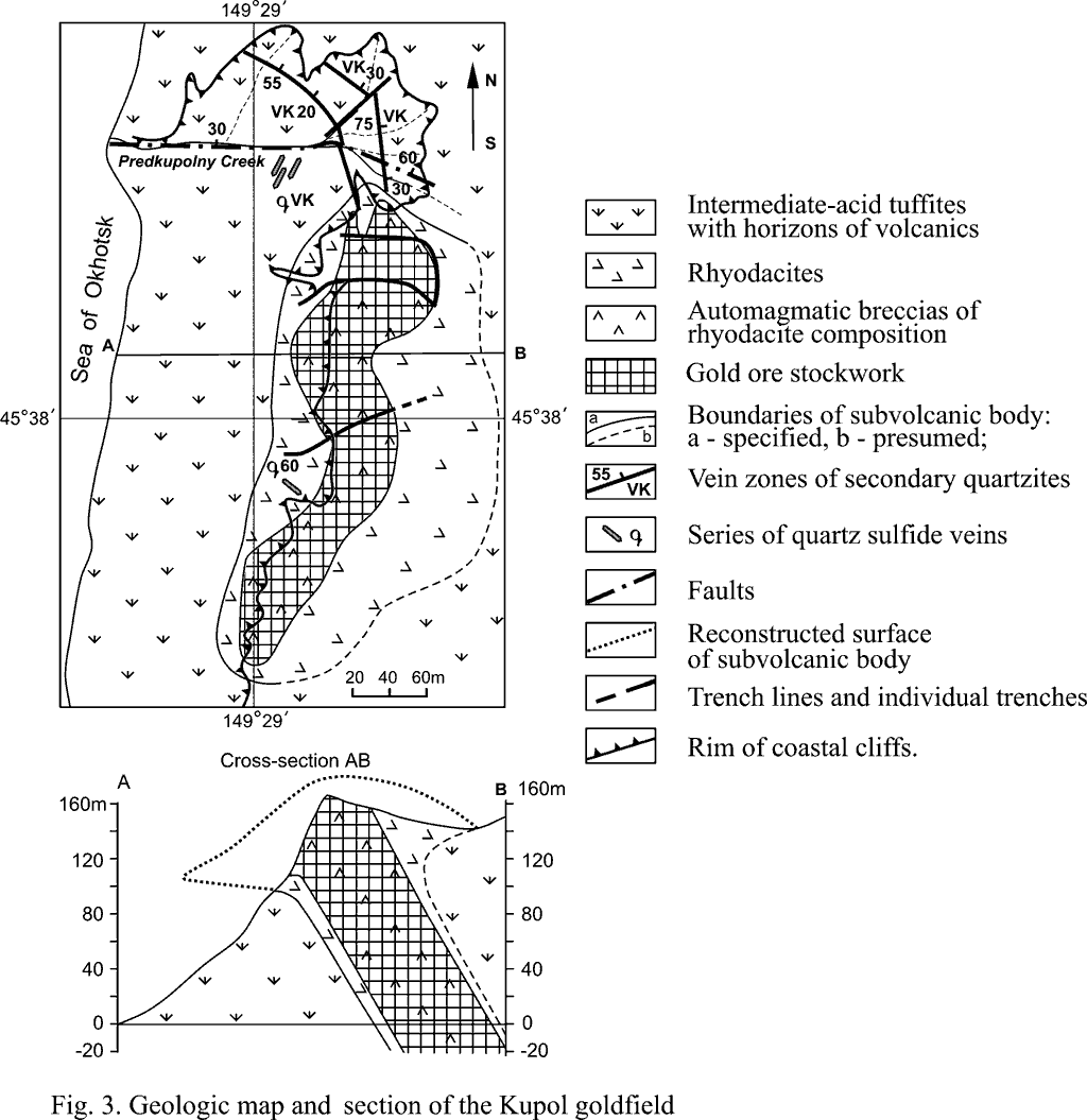
The Kupol deposit (Fig. 3) is located in the inner part of the VTH, where it is distinctly confined to the subvolcanic body of rhyodacites of the Kamuiskiy complex, which intrudes rocks of the Rybakovskaya suite. The features of the composition of the deposit were studied on the basis of trenches intersections across its elongation and by drilling of 11 holes. Morphologically, in the modern relief it is a dome-like uplift. It rises above the surrounding plateau for several tens of meters; however, the absolute height of the uplift above sea level reaches 163 m. Toward the Sea of Okhotsk coast its western part terminates abruptly as a nearly vertical scarp over 100 m high, and more below it turns into a steep slope. In plan the subvolcanic body measuring 160 x 380 m has a form of a submeridionally elongated oval. The major part of the subvolcanic intrusion is made up of automagmatic breccias of rhyodacite. Both breccias and massive rhyodacites have graded into secondary quartzites of hydromica-(sericite)-quartz and hydromica-chlorite-quartz composition. In the marginal parts they are of kaolinite-quartz composition with an admixture of albite, hydrobiotite, adularia, and with dispersedly distributed microcrystalline pyrite. The secondary quartzites form a massive body measuring 90 * 360 m oriented conformably to the rhyodacite strike. On the periphery, the secondary quartzites are fringed with a broad (several hundreds of m) argillization zone. Two series of mineralized (with sulfides and gold) quartz-vein assemblages are distinguished in the secondary quartzites. The first one, streaky-impregnated, is noted for the small thickness of the assemblages and irregular distribution of the ore components. Low-grade gold-silver ores with a content of 2g/t Au are related to it. Thicker (5-20 cm to 0.7-1.0 m) quartz veins make up two systems. The first system is NNE-trending (trend azimuth 20-40°, angle of NW dip 55-65°, sometimes up to 20-40°), subparallel to the body of the quartzites. The second one is NNW-trending (320-340°). Ordinary and rich mineralization and major gold and silver reserves at the deposit with an average Au content of about 25g/t are related to the vein assemblages. The maximal Au content of up to 400-574 g/t characterizes bonanzas (Udodov, Pachin, 2002; Buryak, Naumenko et al., 2002). The streaky-impregnated and the vein series form a submeridionally elongated stockwork measuring 70 x 360 m nearly completely superimposed on the massif of secondary quartzites. A second lithological regularity of the location is the distribution of the quartz-vein assemblages mainly within the bounds of automagmatic breccias. Along the western and eastern endocontacts of the stockwork zones of distribution of isolated vein-quartz bodies 0.5-2.5 m thick each are distinguished. In the vertical section the ore stockwork has been studied in the vertical cliff facing the Sea of Okhotsk coast and by a series of holes. The uniformity of the stockwork structure and morphology of the vein-streaky aggregates is recognized through the whole vertical interval. This allows prediction of persistence of mineralization at least as high as sea level. The principal value of the ore is gold and silver, which are in a positive correlative relationship. The overall copper, lead and zinc contents do not exceed 0.5%. Arsenic and antimony are insignificant (up to 0.03%). The presence of germanium (0.6 to 10.0 g/t), bismuth and molybdenum is noted. The gold/silver ratio in high-grade ores is about 3; Zn:Cu:Pb = 0.13:1:0.03; Te/Se = 0.24; As:Hg:Sb = 45:1:1.8. The ores contain up to 25g/t of rhenium (Danchenko, 1999). According to correlation analysis, direct positive relations with gold are borne by silver, copper, bismuth, zinc, molybdenum and arsenic. By their material composition, stockwork ores belong to the gold mineral type of the gold-silver formation. They formed during several stages of mineral formation, including two productive stages: gold-chalcopyrite-tennantite and gold-hessite. Changes of the first, pyrite-hydromica-sericite-quartz stage and of the second, chalcopyrite-pyrite-hydromica-quartz stage formed a body of secondary quartzites. The first stage forms a mineral association of fine-grained quartz (70-80%), hydromica (10-20%), sericite (10%), epidote (1-5%), and pyrite (1-2%). Metasomatites of the second stage are represented by a gray quartz-hydromica aggregate. In some cases it has a fine-banded structure, and in other cases, a massive and spotty structure. Hydromica plays a markedly more appreciable role (with a content of up to 50%). The quantity of ore minerals does not exceed 1-2%. The samples of the ores that experienced hypergenic transformations (pyrite oxidation with subsequent formation of hydrous ferric oxides, etc.) become brownish and contain numerous leaching cavities. During the above-mentioned stages replacement of volcanic rocks by hydromica-quartz quartzites took place with no gold deposited. Wide development of K-bearing minerals (sericite, hydromica) with carbonates absent give evidence of the formation of quartzites under the influence of K-enriched acid solutions. Following are vein stages involving quartz (dark-colored amethyst-like) and ore minerals deposition. Major minerals of the gold-chalcopyrite-tennantite stage are pyrite, chalcopyrite, and tennantite; an accessory mineral is bornite; and rare ones are sphalerite, arsenopyrite, pyrargyrite, anactite, native silver, proustite, and native gold I. Pyrite is the principal and earliest mineral of the association forming intergrowths with chalcopyrite, bornite, and tennantite. According to microprobe analysis, characteristic admixtures in pyrite are copper (0.1-0.5%, less frequently, up to 2.15%), silver (0.1-0.2%), and gold (up to 0.2%). At the same time, arsenic content in it does not exceed 0.1-0.2%. Chalcopyrite forms allotriomorphic segregations measuring 0.1-0.2 mm which replace pyrite. The main admixture elements in chalcopyrite are silver (0.07-0.24%), gold (0.05-0.24%), and arsenic (0.1-0.2%, less frequently, up to 2.75%). Tennantite forms allotriomorphic segregations measuring 0.05-0.2 mm which replace pyrite and chalcopyrite. According to microprobe analysis, both antimony-free tennantite and Sb-tennantite are developed at the Kupol deposit, with antimony content up to 7-7.5%. Besides, tennantite is distinguished by a low content of silver (0.1-0.2%), and high iron and zinc contents (up to 2-8.4% iron and up to 4-7% zinc). The fact that tennantite from the Kupol area is marked by a low gold content deserves consideration. Native gold I is distinguished by its light color and forms rounded and drop-shaped segregations measuring 0.02-0.05 mm. Less frequent are lamellar segregations and crystal aggregates measuring 0.05-0.2 mm. The surface of the gold grains is uneven, and the edges are rounded. Native gold I is marked by a stable association with pyrite, chalcopyrite and tennantite. It generally forms independent segregations; less often it intergrows with other minerals. Sometimes pyrite and chalcopyrite replacement by lamellar segregations of native gold is observed. Native gold forms lamellar segregations measuring 0.1-0.3 mm in small voids. The formation of minerals of the gold-chalcopyrite-tennantite stage was preceded by intense tectonic movements, after which monoquartzite fragments were cemented by fine- and medium-grained quartz; and in the upper parts of the deposit, by chalcedony-like quartz. The minerals of this stage were deposited from colloid solutions. This is indicated, first, by the banded structure of vein aggregates with alternating crystalline and chalcedony-like quartz; and second, by rounded segregations of pyrite, chalcopyrite and bornite. The absence of adular amid vein minerals is also evidence that the solutions had a weak-acid reaction. After quartz and hydromica crystallization, deposition of pyrite and copper sulfides occurred. The process of mineral formation concluded with deposition of gray ore, pyrargyrite, and native gold I. At the beginning of the gold-hessite stage a fine-grained hydromica-quartz aggregate with the indistinctly banded structure was formed. A major mineral of this stage is native gold II. It forms impregnation and large veinlet-shaped isolated patches measuring 1-3 mm. Accessory minerals are tellurides, hessite, and altaite. Native gold II differs from the earlier gold I in a darker color and a reddish tint, which is suggestive of its higher assay standard (supported by microprobe analysis data). The assay standard of gold based on 6 analyses ranges from 940 to 990 (averaging 970). The characteristic admixture elements of gold are copper (0.11-0.17%), antimony and tellurium (0.05-0.24%), while arsenic content does not exceed 0.04%. This is, evidently, indicative of the presence of tellurium and virtual absence of arsenic in the ore-forming solutions that deposited minerals of the gold-hessite stage. Native gold II in thin sections is observed as several morphological types: 1 -- acute-angled platy gold grains measuring 0.05-0.15 mm; 2 -- gold rims 0.1-0.2 mm thick growing over the void walls in the quartz-hydromica aggregate; 3 -- small rounded segregations measuring 0.01-0.02 mm; 4 -- micron-level gold measuring about 0.005 mm and forming thin rash in the quartz-hydromica aggregate. In crushed samples the following morphological differences of native gold are observed: 1 -- crystal aggregates of gold of the octahedral and cubic octahedral habit and their complex dumbbell-shaped or chain-shaped aggregates, both small (0.1-0.2 mm) and larger ones up to 0.5-1 mm; 2 -- flattened dendrites of gold measuring 0.1-0.2 mm; and 3 -- lamellar segregations measuring 0.1-0.2 mm with pointed edges and a fine-spongy shagreen surface. By and large, gold is rather fine; particles measuring 0.01-0.14 mm prevail. An insignificant part is made up of differences of 0.2 to 0.75 mm. They are mainly represented by idiomorphic crystal segregations and their aggregates; less often, by lamellar film forms. Hessite forms small (up to 0.01-0.02 mm) segregations in the quartz-hydromica aggregate, and also the finest (0.01-0.02 mm) streaks. Of other minerals of silver, besides hessite, in a lesser quantity pyrargyrite, acanthite, krennerite, calaverite, cerargyrite, and native gold are noted. Insignificant distribution of silver minerals in the ores of the Kupol deposit is the main reason for the low content of silver (no more than 30 g/t) the presence of high contents of gold (20-50 g/t). At the gold-silver deposits the underdevelopment of sulfosalts of silver and the high values of the Au/Ag ratio are characteristic of the objects belonging to the gold-hydromica-quartz (Brad in Rumania) and gold-telluride types (Ozernovskiy and Sopka Baranya on Kamchatka). The wide development of hydromica and the chalcedony habit of quartz with metacolloid, cavernous textures and colloform, breccial and crustification structures give evidence of mineral formation in the near-surface conditions (a few hundreds of m). It had its origin in S-depleted colloidal solutions (it is evidenced from the insignificant quantity of sulfides). Later followed crystallization of native gold, both small and thin measuring 0.01-0.02 mm and as large as up to 0.2 mm platy segregations in the voids. The presence of hessite and altaite in the ores and a tellurium admixture in native gold II is indicative of elevated concentrations of tellurium in the ore-forming solutions. The morphology of native gold II (wide development of gold and dendrite crystals) in thin sections and crushed samples suggests its crystallization in conditions of free growth in the voids and fractures. The formation of white combed quartz followed the ore stage. Its streaks cross all the earlier deposited mineral associations. Sometimes kaolinite is observed between quartz grains. Minerals of the acanthite-covelline association belong to the stage of hypergenesis. They are noted for rather widespread occurrence in the Kupol ores. However, their relative portion among other mineral associations does not exceed 10%. The principal minerals of the association are acanthite II and covelline, and the accessory minerals are chalcosine and scorodite. During the hypergenic stage of mineral formation chalcopyrite, bornite and tennantite were replaced by chalcosine and covelline. Incidentally, removal of silver with its subsequent redeposition in the form of acanthite occurred. Later, the formation of hydrous ferric oxides took place. In the 0-160 m interval an increase in the gold/silver ratio (0.09-2.7) and the change of weak reduction conditions (hematite+pyrite+pyrrhotite) by strongly oxidation conditions (goethite+hydromicas) are noted. At the near and distant flanks part of the deposit is accompanied with polymetallic gold-bearing (Au = 1-6.5 g/t) sulfide-quartz veins in the zones of NW faults. Particularly noticeable sulfide mineralization is registered in volcanic rocks of intermediate composition. In the Tetyaev VTS this mineralization is assigned to the earliest one (Danchenko, 1991; Neverov, 1970). Vertical metasomatic zoning in the deposit area is represented from bottom to top by: 1) a propylitization zone with copper-polymetallic and copper-pyrite veins bearing coarse-crystalline quartz; 2) a zone of secondary quartzites with colloform quartz; 3) a zone of low sulfide secondary quartzites with quartz-vein zones bearing commercial gold; and 4) a zone of secondary quartzites with admixtures of hematite, goethite, alunite, gypsum, and native sulfur. According to investigations of the isotope composition of sulfur from polymetallic veins at the Kupol flanks, 34S varies from -6.55 to 3.6%o (in chalcopyrite), from -0.6 to +1.92%o (in sphalerite), and from +2.8 to +4.2%o (in pyrite). Sulfur may have a magmatic source with a possible participation of sulfur of sea water sulphates. The cited values are lower than those for the isotope sulfur composition of deposits in the Miocene green tuff area on Hokkaido, which may be attributed to the more oxidized setting of ore formation (Ishihara, Sasaki, 1995). The age of the ore-hydrothermal assemblages of the Kupol deposit determined from sporadic samples (K-Ar method) varies from 4.0 to 10.6 Ma. It is assumed that there existed an ore-magmatic system at that time related to the formation of the subvolcanic body. The deep-seated interval of quartz veins outstripped on the surface shows the presence of a magmatic channel, along which there was movement of metalliferous hydrotherms. According to V.Ya. Danchenko with co-authors (Danchenko et al., 1997), in the southern part of the Greater Kuril Range the age of the gold-silver ores linked to this stage was determined at 5-4-2; and of polymetallic and barite-pyrite-polymetallic ores, often enriched in rare metals (Te, Se, Mo, Sn, In, etc), at 5 Ma. 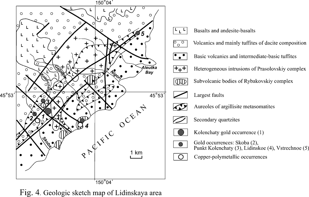
The Lidinskiy ore field about 160 km2 in area extent is located in the eastern part of the island (Fig. 4). The field is made up of volcanogenic-sedimentary assemblages of the Rybakovskaya suite. The main features of the structure of the section are the following: 1) variegated composition of the rocks, 2) mainly coarse fragmental composition with rough-manifested stratification in the lower part and thin flyschoid alternation in the upper part, 3) abundance of volcanic (lava and pyroclastic) material, and 4) greenstone alteration of rocks. At some places the stratified assemblages are intruded by bodies of quartz diorites, plagiogranites, diorite porphyrites, dacites, and basalts of the Prasolovskiy intrusive and Rybakovskiy subvolcanic complexes. Major tectonic elements of the area are faults of the Lidinskaya zone of the normal fault-upthrow type. They are oriented parallel to the eastern boundary of the island in the north-easterly direction (dip azimuths 130, 310°, and dip angles 70-80°). The faults are morphologically represented by closely located subparallel zones of intensive jointing and less often, brecciation. The described rupture dislocations governed the distribution of volcanic centers (appreciably eroded by the present time), intrusive rocks and dike belts. The same faults control a large zone of argillization traced at a distance of 25 km from the Polovinka River (on the south) as far as Vstrechny Creek (on the north). The thickness of the argillisite zone is 1 km on the flanks to 3 km in its central part (Kolenchaty Creek -- Nigori River). Argillization is particularly extensive and intense in the endocontact zones of intrusive and sill bodies of diorite to plagiogranite composition. This suggests the relationship between the magmatic and hydrothermal assemblages. The second system that controls metasomatite zones is the north-western system (dip azimuths 215-230-, and dip angle 65-80-). The third system, whose occurrence is limited, is submeridional. Apart from the described large zone, a less significant zone extending for 3-4 km with a thickness of 0.5-0.7 km (Gnuty Creek basin) and analogous numerous smaller ones are recognized. Elongated bodies of secondary quartzites 8 to 90 m thick extending for 180 to 1000 m were formed within the areas of the most intensive argillisite transformations for the whole extent of the Lidinskaya zone. The following zones, from the periphery to the center, are observed in the larger bodies of secondary quartzites: kaolinite, sericite, alunite, and monoquartz zones. Relict sectors of weakly altered, chloritized rocks are noted in the marginal zones of quartzites. The bodies of secondary quartzites are controlled by the same steeply-dipping deformations as the argillisites, and by areas of faults intersection. They are NE-, NW-, and in some cases, submeridionally striking. Besides, the zones of both argillisites and secondary quartzites can be sheet-like with a subhorizontal dip. This is most notable for the zones of development of gentle rupture dislocations and areas of entry of sill-like intrusions of granodiorite and diorite composition. Hydrothermal alterations in the vertical section develop mainly in the upper, compositionally more acid part of the stratified section of the Rybakovskaya suite. Within its bounds, in the horizontal zones of argillization up to a few tens of meters the fine fragmental cement of tuff gravelites and tuff conglomerates is replaced by minerals of argillisites (kaolinite and hydromica); pebble and dacitic boulders, by quartz matter with an admixture of sulfides (mainly pyrite); and boulders are replaced by limonite and kaolinite. All argillisite metasomatites and secondary quartzites are distinguished by their elevated gold content (Ё few 0.001-0.01 g/t to a few 0.1 g/t). This markedly discriminates them from the surrounding unaltered rocks with low background contents (< 0.001 g/t). Quartz-vein zones with polysulfide, copper, polymetallic-gold-silver mineralization are confined to the secondary quartzites and to a lesser degree, to argillized rocks in brecciation zones. Besides, anomalous (up to 1.3-1.8 g/t) contents of gold have been established in individual bodies of secondary quartzites that replace tufogene-sedimentary rocks of the Rybakovskaya suite. The maximal content of gold in sulfide-bearing veins is 5.4 g/t; and silver, 42-100 g/t. The same veins contain up to 6% copper, and up to 1% zinc. In the quartz gold-bearing veins with sulfides zinc, silver, vanadium, and nickel have direct correlation relationship with gold. The central part of the area (Skoba and Kolenchaty Creek basins) is characterized by the widest development of polymetallic and gold-bearing veins; and an area on the bank of Kolenchaty Creek to the Utesnaya River is to a lesser degree noted for the presence of these veins. The veins are NW- and NE-trending, and their thickness is 0.05 to 0.3 m. The enclosing matter is hydrothermally altered tufogene-sedimentary rocks, subvolcanic andesites, dacites, and tuffs of andesite and dacite composition in the upper part of the Rybakovskaya suite. The gold-bearing veins are made up of metacolloidal and combed quartz with sulfide impregnations. The structure of the ores is brecciated with streaky, impregnated, nested, and cavernous (due to weathering) elements. The ore textures are granular allotriomorphic, less frequently, hypidiomorphic, fragmental, corrosional, emulsional, metacolloidal globular, gel, loop-shaped, granoblastic, erosional, skeletal, sometimes subgraphical. Ore minerals amount to about 20% of the rock volume. They are represented by pyrite (30% of all ore minerals), chalcopyrite (up to 60%), marcasite (7%), goethite (2%), sphalerite (1%), and also individual barite grains. Less often occur cubanite, covelline, chalcosite, melnikovite, pyrrhotite, leucoxene, and tannantite. Individual indications of telluride (altaite) and silver minerals (argentite, cerargyrite, eucairite, and tetrahedrite) are observed. Gold is represented by single segregations in sulfides or occurs as intergrown with them. Its two generations are present. Earlier gold-I with the assay standard 750-800 is represented by small drop-shaped segregations measuring up to 0.04 mm in the ore clasts of sphalerite. The segregations show signs of zonal structure and deformation. Gold-II assaying at a standard of 850-920 is represented by segregations measuring 0.02 * 0.04 mm in the chalcopyrite aggregate which intergrowths with sphalerite, galenite, and pyrite. The Otlivnoe ore field (60 km2) is confined to the VTS of the same name 9-10 km in diameter in the eastern part of the island (Shimdt area). The major part of the structure is formed by УTri SestryФ Pleistocene-Holocene statovolcano. Its basement is flyshoid deposits of the upper part of the Rybakovskaya suite. The Otlivnoe VTS is confined to the intersection of the NE- (coastal), sublatitudinally-, and NW-trending faults system. An arc fault is presumed along the boundaries of the structure. Caldera subsidence of the structure, possibly, took place along the fault to a depth of 100-150 m, according to geologic evidence. The fields of hydrothermal-metasomatic alterations have been identified on the periphery of the structure and its most eroded parts. They have been recognized in moderately acid volcanic rocks and in the Уgreen tuffФ member of the Rybakovskaya suite upper strata: 1) on the volcanoТs western slope (fumarole-solfatara argillisite field replacing dacites with preserved sulfur solfataras), 2) in the basin of Mutny Creek on the north-east of the structure (argillisite field and sulfur secondary quartzites in tuffites), 3) within the paleovolcanic neck in the basin of the Lesnaya River (intense argillization), 4) on the eastern slope of the structure (area of Cape Klyuchevoi -- argillization fields replacing tuffs of dacites), 5) in the southern part of the structure (right bank of the Doroshenko River -- argillisite fields; kaoline and alunite secondary quartzites in tuffites), and 6) in the north-western part of the structure -- areas of argillized rocks and kaolinite secondary quartzites with quartz veins (Otlivnoe occurrence in tuffites). The altered rocks, including secondary quartzites, are controlled by both steeply- and gently-dipping rupture dislocations. In the upper reaches of the Doroshenko River, in the Cape Klyuchevoi area and at the Otlivnoe occurrence recent sulfur springs, including thermal ones, have been detected. The gold potential of the hydrothermal-metasomatic assemblages of the Otlivnaya VTS is understudied. In a number of cases, elevated gold contents (a few 0.01 g/t to a few g/t) have been established for sulfur quartzites and quartz veins (Mutnaya River basin and Otlivnoe occurrence). The Otlivnoe occurrence of polymetallic, sulfosalt-orpigment-realgar and gold-silver ores is the best studied within the volcano-tectonic structure. The occurrence is formed by active (recent) chloride-sodium springs with pH=6.5-6.6 and temperature 50-83°C (Danchenko, 1999). It is represented by a zone of opal-chalcedony-quartz-sulfide streaks and breccias on the secondary quartzites; the latter replace subvolcanic andesites and granodiorite porphyries, and (chiefly) tuff gravelites of the Rybakovskaya suite. Ore minerals (up to 30-50%) are represented by pyrite, chalcopyrite, kesterite, marcasite, chalcosite, bornite, covelline, barite, sphalerite, realgar, orpigment, which frequently cement present-day beach deposits. Zn (7.5%), Cu (3.05-5.0%) and As (up to 1.9%), dominating in the ores, are accompanied with (g/t) Au (1.3), Ag (200), Sn (427), In (100), Hg (237), Cd (1000), Bi (8000), Mo (118), Ti (100), Ge, Sb (300), given Au/Ag = 0.02; Te/Se = 2.1; Zn:Cu:Pb = 4.15:1:10.45; SiO2/Al2O3 = 8.8; Na2O/K2 = 0.58; (FeO + Fe2O3) = 0.37. The occurrence is an example of recent low-temperature acid-sulfate silicic-potassium metasomatosis which forms complex Au-Ag-bearing sulfide-sulfoarsenide ores. The Desant (Kastrikum) ore field occupies the whole north-eastern part of the island. The area is made up of volcanogenic-sedimentary and sedimentary assemblages of the Rybakovskaya suite intruded by subvolcanic diorite-porphyry bodies of the Rybakovskiy complex and plagiogranite-porphyries of the Kamuiskiy complex. The mineralized zones of hydrothermally altered rocks are controlled by NW and NE tectonic deformations. Gold-silver mineralization is noted in quartz-sulfide veins, mineralized zones, and in secondary quartzites in the Krasnykh Skal Bay area and in the basins of Tumannyi Creek and Vodopadnaya River. The largest location of mineralization is observed in a pole-shaped NW-pitching stockwork body of quartzites with an angle of dip of 70° and a diameter of up to 10 m. The quartzite body was formed at the intersection of two NE- and sublatitudinally-trending faults in the zone of development of volcanogenic-sedimentary rocks of the Rybakovskaya suite. The brecciated secondary quartzites contain gold up to 10 g/t, silver up to 100 g/t, zinc up to 100 kg/t, lead up to 50 kg/t, and copper up to 10 kg/t. In the occurrence area, in the argillization zone traces of exploration of Au carried out by Japanese workers have been detected -- more than 30 adits, cuttings and inclines. The Okeanskiy ore field in the south-eastern part of the island is understudied, regarding its gold potential. The main structural element of the area is the zone of a NE-trending longitudinal fault. The zone controls distribution of productive zones of secondary monoquartzites, quartzites, and quartz breccias with quartz-pyrites and polymetallic mineralization with elevated contents of gold (0.n g/t). No gold placer deposits have been detected on the island. This can be due to unfavorable conditions for placer formation. Rivers on the island are mountain streams; they have a steep longitudinal profile, and run directly along the rocky channel in their upper reaches and middle parts. All this helps grinding of gold to its powered condition and removal it into the sea. At some places of sea (and ocean) beaches with rich УheavyФ magnetite high-density mineral sand, local sand enrichment in gold is possible; however, this issue was not considered before and needs special investigation. CONCLUSION Gold mineralization on Urup Island is referred to a commercially major gold-silver quartz-vein type, possibly, to the gold-silver-porphyry type (Kupol deposit). The mineralization is spatially associated with volcano-tectonic structures and fault zones. The ores of all occurrences belong to the Au-Ag formation. Besides, the ores of the Kupol deposit can be assigned to the gold-silver-telluride genetic series of volcanogenic epithermal deposits of gold, and according to V.G. KhomichТs classification (1995), to the gold-telluride geochemical type. The latter, as M.M. Konstantinov (1984) believes, is distinguished by predominance of gold over silver, high-grade gold with an admixture of tellurium, top-down change of gold ores by polymetallic, and association with small acid intrusions. According to V.Ya. Danchenko (1991), they belong to the gold type proper (Tetyaev and Lidinskaya areas) and the gold-bearing sulfide-sulfosalt type (Otlivnaya VTS), based on the mineral varieties of ores. The favorable structural settings of location of gold mineralization include the following: 1) zones of NE- and NW-trending faults and zones of gently dipping rupture dislocations; and 2) peripheral and inner parts of volcano-tectonic structures, most disturbed tectonically by arc and linear rupture dislocations. The most important lithological factor of location of mineralization is its confinement to 1)more acid rocks of the tufogene-sedimentary section tops of the Rybakovskaya suite of the Уgreen tuff formationФ; 2) zones of endo- and exocontacts of subvolcanic bodies of rhyolite to rhyodacite and plagiogranite composition; and 3) small intrusions of acid composition (mainly of the Kamuiskaya suite). Mineralization accompanies volcano-plutonic complexes of each stage, particularly magmatic assemblages of the Kamuiskiy complex. Ore mineralization changes from mainly multisulfide pyrites and pyrites-polymetallic to essentially gold-silver-low sulfide. Late Cenozoic gold deposits, whose formation is linked to magmatic and hydrothermal processes that attend plate subduction in the island arcs area, are widespread in the eastern Pacific. Analogous deposits (in terms of location and belonging to a certain formation) are gold-telluride deposits of other island arcs (for example, on Guadalcanal Island of the Solomon Islands, Emperor deposit on the Fiji Islands (Kovalev, 1978; Eaton, Setterfield, 1993). Besides, given the development on Urup Island of moderately acid and intermediate subvolcanic intrusions with related pyrite and chalcopyrite mineralization, porphyry-copper deposits with gold can be predicted. Similar ore objects (Pasca-Lama in Chile, Apococha in Peru, etc.) with large reserves of gold and silver in secondary quartzites have been identified in Miocene volcanic belts in South America (Petford et al., 1994; Kay, Mpodozis, 2001). Mineralization in secondary quartzites on Urup Island is analogous by some features (stockworks of gold- and silver-bearing quartz vein in secondary quartzites) to other gold objects in volcanic structures, for example, the Belaya Gora deposit in the Lower Amur region (Mishin, Berdnikov, 2003) and the Prasolovskiy deposit of the gold-telluride-quartz subformation on Kunashir Island (Danchenko, 1991). The Urup ores and Hishikari volcanogenic deposits are united by low sulfide content, low temperature of formation, morphological features of the ore bodies, and their location in sedimentary, tufogene and volcanic rocks. On the other hand, the Urup ores differ from the Hishikari deposits in the structural position: the latter are related to the post-subduction transform stage of development of island arc belts (Rodionov, Khanchuk, 1997; Izawa et al., 1990). The most promising areas for the search for gold of the gold-silver formation in quartz veins and in secondary quartzites on the island are the following: 1) Lidinskiy (NE-trending fault zone in the eastern part of the island); 2) Tetyaev volcano-tectonic structure in the south-western part of the island; 3) Shmidt area (УTri SestryФ volcano-tectonic structure and its nearest flanks); 4) Kastrikum area of the Desant volcano-tectonic structure (north-eastern part of the area); and 5) Iwao volcanic structure (south-western part of the island). Gold occurrences within the studied areas can be observed at different levels of their erosional truncation, but chiefly within the moderately eroded volcanic structures. The Lidinskiy area (Nigori River -- Kolenchaty Creek basin), Tetyaev area and its flanks, and Kastrikum area, which are distinguished by the maximal degree of erosion, can be regarded as promising for detection of the porphyry-copper (with gold) type. On the other hand, areas of development of rocks of the lower horizons of the Rybakovskaya suite, Fregatskaya and Bogatyrskaya suites, which are little subjected to hydrothermal alterations, can be rated as having little potential with respect to detection of mineralization. Thus, the prospects of the island for detection of gold (and also copper-polymetallic with gold) deposits can be rather highly assessed. The most important criteria of possible large-scale ore formation can be regarded the following: 1) wide development of Уgreen tuffФ units commonly enclosing Kuroko mineralization and gold-silver mineralization in quartz veins (Japanese Islands); 2) large-scale occurrence of acid magmatism, to which one links ore formation in the southern part of the Greater Kuril Range; 3) favorable structural settings (volcano-tectonic structures, extensive zones of faults and centers of their intersection; and 4) wide occurrence geochemically gold- and chalcophile element-specialized hydrothermal metasomatic assemblages (secondary quartzites, argillisites, and quartz veins). References:
Vadim Ye. Kirillov Tel. (w.): (4212) 31-35-65 E-mail: vekir@itig.as.khb.ru |